Bronte Falls, West Yorkshire UK
• 5-star hike
• 4 to 6 mile options
• Easy & Moderate | Gain 160-260m (520-840ft)
• Haworth, UK | United Kingdom
.

Brontë Bridge, close to the Falls.
Growing up in isolated and rugged West Yorkshire, the famous literary sisters of the Brontë family would incorporate their surroundings into novels that included Jane Eyre, Wuthering Heights, Agnes Gray and The Tenant of Wildfell Hall. In fair weather the sisters would often walk the moorlands above their Haworth home and a hike to what later became known as the Brontë Falls was a popular destination. A little further up the hill is the ruins of Top Withens, said to be an inspirational location for the setting of Emily Brontë's Wuthering Heights.
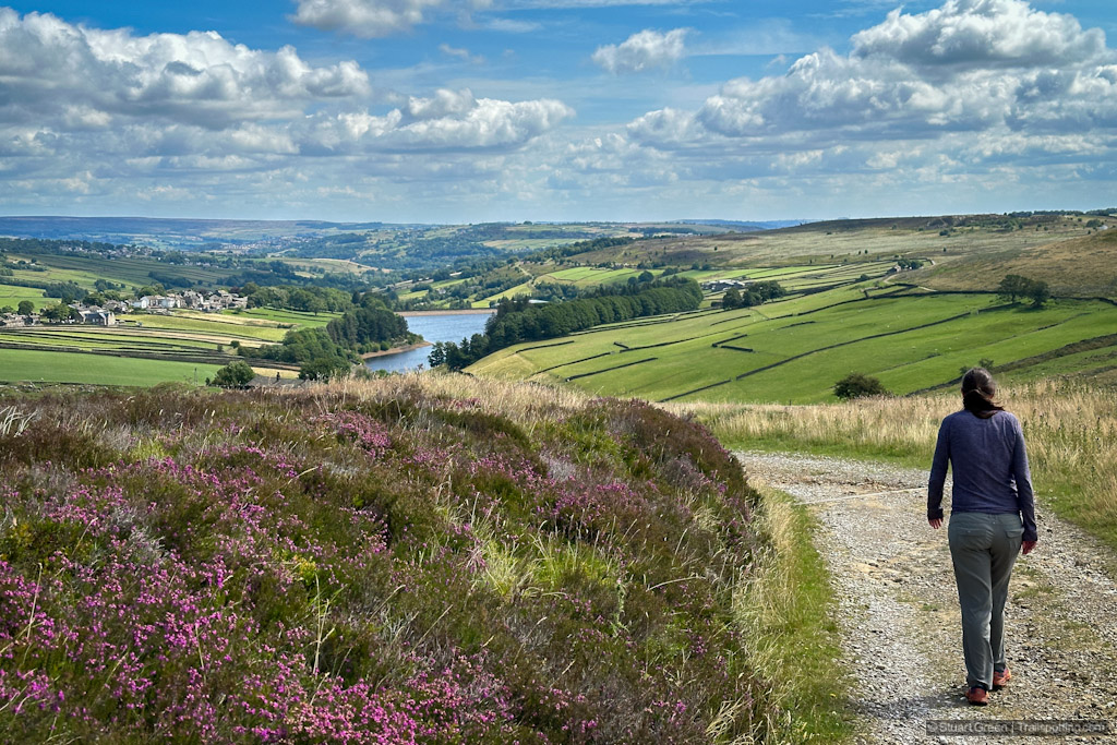
The loop trail to Brontë Falls crosses exposed heather-covered moorland on a mostly flat pedestrian trail that for a time joins up with a farm track and makes for an easy surface. The open views across a shallow valley of dry stone walls and sheep farms provide scenic backdrop for this hike. Dropping down slightly to Sladen Beck you'll find the slender Brontë Bridge spanning the narrow waterway, and the small yet picturesque Brontë Falls are just a short excursion further upstream.
| ⬤ 5★ Brontë Falls Loop
GPX File · AllTrails · DirectionsGPX? |
| ⬤
5★ Top Withens Loop
GPX File · AllTrails · Directions |
| P Free parking |
Completing this hike as a loop trail requires a minor hill-climb up the other side of the stream and cutting across several farm fields. Though this increases your elevation gain, your efforts are rewarded by even more excellent views - particularly towards Lower Laithe Reservoir to the east. Two-thirds of the return journey however is on pavement - first along quiet farm roads, then through the small village of Stanbury which includes a couple of public houses on the way. More uphill walking is required to return to the trailhead along Reservoir Road and past Lower Laithe Reservoir.
Adding Top Withens to your hike will add a further two miles to your journey, but you'll get to enjoy elevated scenic views and perhaps feel a little closer to Cathy and Heathcliff from the novel. The trek up the moorland to Top Withens can get a little boggy at times.

Moorland and sheep farms on this easy scenic trail.
Our preferred trailhead and parking area is at the southeast corner of the hike, on Moorside Lane at Penistone Hill Country Park. There are free spots very close to Moorside Lane, but even more if you drive further into the park. We also identified several other alternative parking locations close to Stanbury. Public bussing also serves this area.
Though Charlotte, Emily and Anne each found great success with novels that are now regarded as literary masterpieces, their works were published under male pseudonyms and it only after their deaths at young ages that they became to be well known. Today many readers make the journey to visit the Brontë Parsonage Museum in Haworth, which is located only a mile from this hike. You can also visit Anne Brontë's grave in the popular Yorkshire seaside resort of Scarborough, from where we feature a great coastal walk.

Walking the return leg, towards Lower Laithe Reservoir.

Lower Laithe Reservoir, opened 1925.
Tangents:
• AllTrails Public: Bronte Waterfalls Circular
• Facebook Group: Comment, Follow Us


